|
|
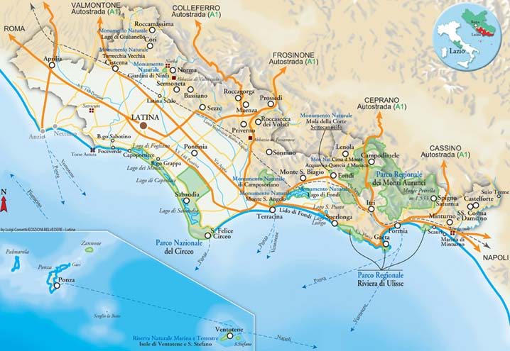
MUNICIPALITIES IN THE PROVINCE
|
Aprilia
This is the youngest city in the province of Latina; it was founded on 25 April 1936 and inaugurated 18 months later, after the extensive reclamation work at the Pontine Marshes had terminated. Aprilia’s original small centre was destroyed during World War Two, but the town recovered in an extraordinary manner, so much so that in a few decades it be-came the second most populated city in the province and one of the largest in the Latium region. The town’s economy is based on...
Continue
|
|
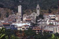
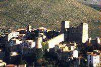
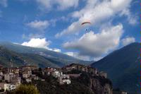
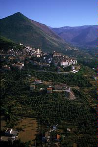
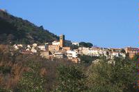
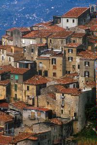
Bassiano
Surrounded by mountains and dominated by Mt. Semprevis, the highest of the Monti Le-pini (1536 m.), the town stands on a hill (562 m.)completely submerged in green woods, making a summer holiday particularly delightful. The town, enclosed within a ring of walls dating from the 12th-13th century, with nine towers and three gates, winds a spiral around Piazza della Torre and is rich in medieval and renaissance architecture.
This is where Aldo Manuzio the Elder, a 16th century ...
Continue
|
|
Campodimele
Paesino posto su di un colle conico all’altezza di 647 m., tra una cerchia di monti nei pressi del punto di contatto tra la catena Ausona e Aurunca, Campodimele vanta l’invidiabile privilegio, confortato da dati statistici inconfutabili, di avere una popolazione tra le più longeve del mondo. Il centro è a forma piramidale, con raccordi interni affidati a piccole scalinate che conservano ancora integra la suggestione del passato. Tra i monumenti e ...
Continue
|
|
Castelforte
This is the last centre in the Monti Aurunci, situated on a small hill overlooking the Ga-rigliano Plain. With Minturno it shares the border between Lazio and Campania. Al-though it was born before Rome, the present town centre is clearly of mediaeval origin. It belonged to the Caetani family, who built the castrum forte to guarantee control of traffic in the Gariglian valley, and later passed to the Colonia and Carafa families. The main constructions of the period are the wa...
Continue
|
|
Cisterna
Situated along the Appia Way, on the route which St.Paul was taken as prisoner on his journey to Rome. Cisterna was probably the Roman settlement of Tres Tabernae men-tioned in the Acts of the Apostles as one of the two Pontine localities (the other being Forum Appii) where the Apostle met groups of Christians. The city developed greatly and enjoyed its “golden age” under the dominion of the Caetani family, which extended its territory as far as the Lago di Fogliano (the lake...
Continue
|
|
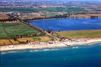
Fondi
The semicircle of the Ausoni and Aurunci Mts. That terminates at Terracina and Sper-longa, delimits the broad Fondi-Monte S.Biagio Plain, in which rich karst springs form Lake Fondi. The plainends at a coastline of the Fondi area that extends for over 10 kms. A strand of dunes, hich is still partly unspiled and hosts primitive vegetation, accompa-nies the sea, highlighting the seaside nature of this land, whose capital lies in the interior. According to legend, the town wa...
Continue
|
|
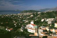
Formia
The origins of Formia are linked to the legend of Troy and Ulysse’s travels on his return journey. Of pre-Italic and Aurunco formation, as demonstrated by the ring of polygonal walls and numerous other remains scattered all over the territory, Formia, placed in the centre of the Gulf of Gaeta and protected from the cold winds by the high hills, was, even in Roman times, a popular holiday resort and conserves the ruins of numerous villas, and was chosen by such an important f...
Continue
|
|
Gaeta
Rising on the spur of Monte Orlando is Gaeta, a maritime republic and holiday resort area since ancient Roman times, as evidenced by various vestiges remaining in the terri-tory. Today’s Gaeta is a bathing resort of the middle Tyrrhene that benefits highly from a temperate climate, receptive facilities and structures and good quality bathing beaches, in addition to ample historic, monumental and religious evidence, from various epochs. Its coastline is a sequence of beaches ...
Continue
|
|
Itri
Itri links the Monti Ausoni and Aurunci and is situated at a height of 170 metres on the slopes of the latter. It has a small stretch of coastal territory. The oldest and most interest-ing settlement, with dwellings in pyramidal groups round the castle, lies on the Colle St.Angelo. The most modern centre is situated on the plain, along the Appian Way, of which some sections can still be seen, as well as funerary monuments and strong retaining walls. Preciou straces or the med...
Continue
|
|
Lenola
A well-known farming centre, this was in an ancient times a major transhumant route linking the Liri Valley with the Fondi Plain. Surrounded on three sides by the Mt.Ausoni, it overlooks the Fondi Plain and the lahe of the same name to the south. The mediaeval urban centre occupies the highest part of the hill (425 m.) with a defence system consist-ing in a ring of walls, arranged in the tradiotional enveloping plan, houses packed close together, narrow streets and flights of...
Continue
|
|
Maenza
This is a well-conserved mediaeval centre that has practically maintained its original ur-ban structure intact, growing up around the mediaeval stronghold at a height of 358 m.. There are dwellings, high passages and tower-houses. Behind it , marking the boundary with the province of Frosinone, is Mt. Calvello (935 m.) and the large areas blanketed with chestnut, beech and ilex trees; its slopes lead to the Amaseno Valley. The main his-toric and monumental features is the Roc...
Continue
|
|
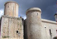
Minturno
Located on a hill overlooking the coastal villages of Scauri - the ancient Pyrae - and Ma-rina di Minturno, the town has very ancient Auruncan and Roman origins. Il was built on the shores of the Garigliano river, which today marks the borders between the Province of Latina and Latium and the Province of Caserta and Campania. The Garigliano river is spanned by the old chain bridge built by the Borboni in 1828, which has since been completely restored. In the area there is on...
Continue
|
|
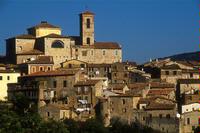
Cori
Standing amidst a vast espanse of olive groves and vineyards, on a small conical hill (398 m.) behind Mt.Lupone (1378 m.), the town position makes it a quite residential area. Of particular interest among the various uncontaminated natural habitats is the area of Fontana del Prato, the slopes leading inland and the two natural monuments Lago di Giulianello and Torrecchia Vecchia.
Still well conserved, Cori has a characteristic mediaeval urban fabric with streets, steps and ...
Continue
|
|
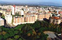
Latina
Four new towns were built in this area from 1932 to 1937. Latina was the first of these, founded on 18 December 1932 with the name of Littoria. It was probably populated by a great number of immigrants from the Veneto end Emilia Romagna regions, as well as from Abruzzo, Marche and other towns in Latium. The new setllers were given the thou-sands of farms built by the Opera Nazionale Combattenti (Natl. Veterans’ Organization) and the Università Agrarie (Agrarian Universities)....
Continue
|
|
Monte S.Biagio
This town was part of the Kingdom of Naples and was its northernmost land on the bor-der with the Papal State. It is situated on a small hill 133 metres high, detached from Mt. delle Fate (1090 m.) and Mt. Calvo (1038 m.). The urban structure consists in a nucleus of buildings resting against the bare rock, narrow streets that turn into flights of steps and lead to the top of the defence system and the remains of the castle, which affords a sweeping view of the Fondi Plain...
Continue
|
|
|
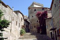
Ninfa
Continue
|
|
Norma
Situated at 410 m. on a sheer rocky spur (la Rave), this dominates the Pontine plain. The origins of the present town date from the Middle Age but its name is derived from the ancient Norba, destroyed by the Romans in 82 b.C. and never reconstructed, which stood at Civitas, approximately a kilometre away. Of the so-called “stone town” today you can still see the impressive remains of the great polygonal walls approximately 2300 metres long, broken by gates and the Loggia bast...
Continue
|
|
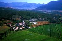
Pontinia
Inaugurated on 18 December 1935, exactly one year after the first stone was laid, Ponti-nia was named after the region in which it lies. The original town, which is still intact, is much like the other “new towns”, consisting of essential but rigorous buildings placed around the central plaza or nearby; the Palazzo Comunale, which still bears its Fascist in-scriptions, the Post Office, the cinema-theatre, the Casa della Cultura (Cultural Centre), the parish church of S.Anna...
Continue
|
|
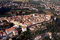
Priverno
Home of Queen Camilla and the Volsci capital, this was born out of the destruction of Privernum (329 a.C.), which stood at Mezzagosto, on the plain crossed by the Amaseno river, now an archaeological site. The old mediaeval centre is arranged in a circle around the main square with the Cathedral of St. Maria and the Town Hall. Other works of his-toric interest area Palazzo Antonelli, part of the defence walls with the gates, palaces and tower-houses incorporated in the urban ...
Continue
|
|
Prossedi
Situated on a hill on the border with the province of Frosinone, at the base of which lies the Amaseno valley, this has a hamlet (Pisterzo) which is actually a village in itself. Sev-eral intervention made during the 18th century altered the mediaeval urban space, such at the Belvedere and church areas. However there are still sections of wall, the Romanesque church of St. Nicola, situated at the top of a small flight of steps, the baronial palace with moat, gate with clock a...
Continue
|
|
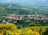
Roccagorga
Abounding with olive groves and alternating bare and wooden stretches, Roccagorga has conserved certain ancient traditions virtually unchanged, such as that of the large bonfire lit on the night of Good Friday for the procession of Christ. It stands on a small hill at a height of 289 m., a spur of Mt. Nero (548 m.), and is surrounded by Mt. Castellone (1018 m.) Mt. Difesa (923 m.) and Mt. Sentinella (1100 m.). The origins of Roccagorga date from the 9th century, following t...
Continue
|
|
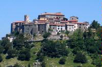
Roccamassima
Standing atop a hill at 746 metres, this is the highest centre in the province of Latina. The road leading to this small town climbs around the cone of the hill to increasingly sweep-ing views of Velletri and the Pontine plain. The nearest peaks are Mt. Pratiglio (945 m.) and, on Roman provincial territory, Mt.Grugliano (1080 m.). The ilex and oak woods here are of excellent environmental value. The town is thought to have developed in the nearly 7th century a.C. on the ruins...
Continue
|
|
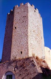
Roccasecca dei Volsci
This stands on a spur of Mt. Curio, at the base of which flows the Amaseno river. Its ter-ritory is bound to the east by Mt. Alto (821 m.), to the south by Mt. Curio (616 m.), by Mt. Le Sirene (711 m.) to the west and by the Amaseno valley to the north. Te area abounds with woods and pastures. Ilex, chestnut, hornbeam and elm trees grow on the north-east side. The mediaeval core of the old centreremains virtually intact, with narrow streets arranged in concentric rings lea...
Continue
|
|
Sabaudia
An oasis. This is the only word that adequately descrive a city where nature delighted in leaving its most beautiful marks: the large Selva del Circeo forest, the long and impres-sive coastal dune rich in Mediterranean vegetation, the Monaci, Caprolace and Paola lakes, the archaeological ruins, the ever-present sea and the sun. You can get to Sabaudia by taking the S.S.148 Pontina highway, but if you are not in a hurry, there are two alter-native routes that will certainly re...
Continue
|
|
|
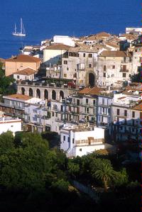
Scauri
Continue
|
|
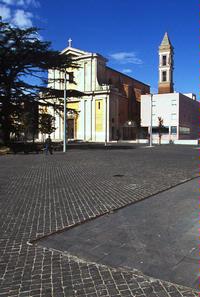
SS. Cosma e Damiano
This is the southernmost commune in the province of Latina together with Castelforte with which it virtaully forms a single centre overlooking the Garigliano Plain. In the up-per part of Santi Cosma e Damiano is the hamlet of Ventosa, which has a fine tower and the remains of watch and defence towers; it conserves the craft of staw-working. Of the ancient buildings, nearly all destroyed by Worl War II bombing, Palazzo Tibaldi and the church of Santi Cosma e Damiano survive. ...
Continue
|
|
San Felice Circeo
Going backwards in time, prior to the periodo f written history, the S.Felice Circeo region was the theatre of one of Ulysses’ adventures: it wash ere that he was attracted by the sorceress Circe and lived for a long period, protected from her magic charms with the help of Hermes. The long history of S.Felice Circeo is revealed in the finds on exhibit at the Homo Sapiens et Habitat Permanent Exhibition, and above all in the coastal caves where archaeologists found the 50,000 ...
Continue
|
|
Sermoneta
This stands on a small hill and it is surrounded by olive groves, chestnut trees and, in the hihest part by beech woods. This is the most unspoilt and interesting mediaeval centre in the Lepini, with an urban structure contained entirely within the ring of walls. Of consid-erable interest is Caetani Castle, restored in the early 20th century by Gelsaio Caetani. Equally interesting are the Collegiata of St.Maria , situated at the centre of Sermoneta; the church of St.Giusep...
Continue
|
|
Sezze
Situated on a hill overloking the Pontine plain, with Mt. Semprevisa behind it, this is se-parated from Sermoneta hills byy a small valley through which flows the Brivolco river; on its sides is a long reddis fissure called Riparo Roberto, where schematic drawings of prehistoric figures can be seen. One in ochre (now detached) dates at least 3000 b.C. and portrays a man. Of Volsci origin, ancient Setia then fell under Roman domain. The re-mains of the polygonal walls, streets...
Continue
|
|
Sonnino
This stands on a hill 430 m. high. The surrounding hills, with Monte delle Fate and the Camposoriano Valley, connect the territory of Sonnino with those of Terracina and Monte San Biagio. As all over the Monti Ausoni, the landscape alternates barren slopes, Mediterranean maquis and olive groves with woods of ilex, oak and juniper trees. The town is of Roma origin and divided into four districts. Today’s old centre, of mediaeval origin, has winding streets, flights of steps, t...
Continue
|
|
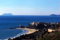
Sperlonga
Lying along Via Flacca, Sperlonga is a charming seaside village, standing on the rocky spur of the Monti Ausoni, Mt. St.Magno., and whose shores are licked by the Thirrenian Sea. Its original tranquillity made Sperlonga a favourite holiday place among the Romans, and it is today a happy seaside resort, still closely linked to its agricultural traditions and full of characteristic surprises: narrow lanes which wind steeply up to the top of the hill, arches which link the bri...
Continue
|
|
Spigno Saturnia
This is one of the classical “twin towns”, with characteristically mediaeval Spigno Vec-chio, situated on a saddle in the Monti Aurunci (375 m.) and protected all around by higher mountains (Petrella, St.Angelo and Redentore); Spigno Nuovo started to develop on the plain in 1946, along the main Formia-Cassino road. This distancing from the hill area led to a reduction in the ancient farming crops although oil and olives, market vege-tables, ricotta and other cheeses remain. T...
Continue
|
|
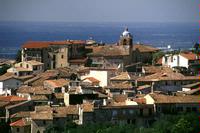
|
Suio Terme
Continue
|
|
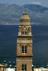
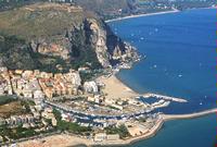
Terracina
Slightly more than 100 kilometres from Rome and 120 kms from Naples, Terracina lies on about 15 kms. Of coastline, along the wide gulf marked by the Circeo and Gaeta promontories. A visual summary of the history of Terracina is afforded by the present-day main plaza, Piazza del Municipio, which has sections of the ancient Roman Appian Way, the Republican Age (or Emilian) Forum with its original pavement, traces of the Roman theatre, and the capitolium. The Middle Age is repre...
Continue
|
|
Ventotene
Snaking through the sea at a latitude of 40°47’10” and 40°48’15” N and a longitude of 0°57’25” and 0°59’ E on the Rome meridian, the island of VENTOTENE was created via the deposition of andesite, basalt and tuff effusions following the explosion of a series of underwater volcanoes. Stretching to 2.7 kilometres in length and 850 m in width and standing no higher than 139m above sea level at its highest point (Monte ...
Continue
|
|
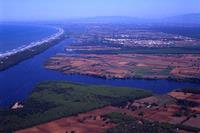
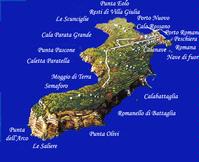
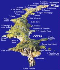
Ponza
One of the most interesting islands in the Mediterranean Sea, PONZA (located at a lati-tude of 40°54’ N and a longitude of 12°58’ E) stretches to approximately 7,350 metres in length (from Punta della Guardia to Punta dell’Incenso ) and varies in width from a max-imum of 2,000 metres to a minimum of just 200 metres (between Cala d’Inferno and Cala dell’Acqua). Covering a total surface area of approximately 722 hectares, the island can be reached by ferry from Formia, Terracin...
Continue
|
|
|
