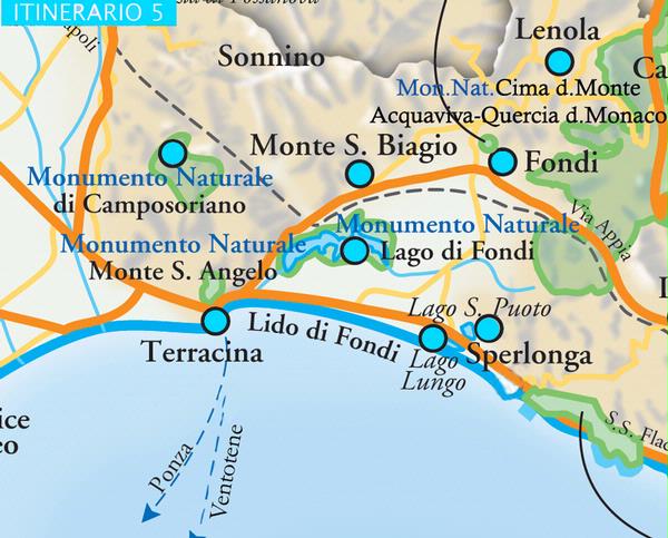
ITINERARIO TERRACINA-CAMPO SORIANO-LAGO DI FONDI-MONTE S.BIAGIO-VALLE S.VITO-LENOLA-FONDI-LAGO S.PUOTO-LAGO LUNGO-TERRACINA
Torna all'elenco
(Length: about 60 km. The Fondi-Monte San Biagio plain and the Ausoni and Aurunci mountains). Located at the foot of the Ausoni mountains on the border between the Pontine and the Fondi plains, the town of Terracina stretches over approximately 15 km of coastline between the Circeo promontory and the town of Gaeta. Originally settled by the Vulsci (Anxur), the area has been inhabited in various ages, evidence of which is clear in Piazza del Municipio; the Roman ruins of the Emilian Forum, the ancient Via Appia, the Theatre and the Capitolium are juxtaposed with medieval buildings such as the cathedral of S. Cesareo, Palazzo Venditti, Torre dei Rosa (now home to Pio Capponi Civic Archeological Museum) and, further afield, Frangipane castle, the 18th century Palazzo Braschi (built by Pope Pius VI) and Palazzo della Bonifica. Proof of Roman presence in the area can also be seen in the shape of the Pesco Montano, cut by Emperor Trajan in 312 BC in order to let Via Appia through to the sea, as well as the Roman Port, the Severian Port and, on Mount Sant’Angelo, the hillside dominating the town, the Temple of Jupiter Anxur (4th century BC). The religious buildings of interest in Terracina include the church of San Salvatore, the church of Purgatorio and the Sanctuary of the Madonna della Delibera. Behind the town, at approximately 300 metres above sea level, lies the Camposoriano, a natural monument characterized by a series of spectacular rocky spires. Taking the SS 7 Via Appia out of the town across the intersection with SS 213 Via Flacca, it is possible to flank Lake Fondi, a coastal lagoon connected to the sea by the Canneto and Sant’Anastasia channels, while the Epitaph Tower (Torre dell’Epitaffio), a Roman burial chamber whose marble stones mark the southern perimeter of the Papal State, lies prior to the strip of “no man’s land” which heralded the commencement of the Kingdom of Naples at Portella (Monte San Biagio). Two kilometres after Portella, a left hand turning leads to MONTE SAN BIAGIO, a small village located on a spur of Monte Calvo. Clustered around the slopes of the mountain, the lanes and stairways of the village all lead up to the castle (closed to the public) which dominates the houses below. Almost in the middle of the village, the church of S. Giovanni Battista conserves a 16th century triptych by Cristoforo Scacco, while the other religious buildings in the village include the tiny church of Madonna della Mercede, the church of S. Rocco and the church of Madonna della Ripa. Returning to Via Appia, at Vallemarina it is possible to see the ruins of a number of Roman tombs, including the mausoleum of Emperor Sergius Sulpicius Galba who was born in the village. A few kilometres to the left of Monte San Biagio lies the Valley of San Vito, an area of particular natural beauty and home to the tallest cork wood in Italy. Returning once again to Via Appia, at Fondi, we take the turning for LENOLA (425 metres above sea level), a village which, surrounded on three sides by the Ausoni mountains, is said to have been established 1500 years before Christ on one of the main migratory routes over the valley of the River Liri and the Fondi plain. Surrounded by a city wall, the village occupies the upper part of the hill which is straddled by numerous streets, lanes and stairways all leading to the baronial palace at the top of the village. Among the places of interest in Lenola are the church of San Giovanni Evangelista, the church of Santa Maria Maggiore, the church of Santa Croce and the church of the Benigne Grazie as well as the Sanctuary of Madonna del Colle in which there is a highly venerated image of the Virgin and Child. The sanctuary can also be reached via the delightful Scalinata della Pace staircase which is decorated with mosaics and bass-reliefs. Returning to Via Appia, the next place of interest along the coast is the ancient town of FONDI which stretches from the slopes of the Ausoni mountains to the sea and extends over approximately 10 km of coastline. (FONDI-LIDO). Certainly of Italic origin, as testified by the cyclopean walls, the town flourished in Roman times and, indeed, is still laid out according to a cardus-decumanus plan. The cultural and architectural features of the town include the Castle (with Civic Archaeological Museum), Palazzo del Principe, St. Peter’s cathedral, the Jewish quarter and the 15th century church of Santa Maria Assunta, while outside the city walls are the church of San Francesco and, at the northern entrance of Via dell’Appia, the tiny church of Madonna del Soccorso. Other places of interest include the ruins of the abbey of San Magno, and, on Mount Arcano, the tiny Sanctuary of Madonna della Rocca. Just to the west of Fondi it is possible to visit the Natural Monuments of Lake Fondi and the Mola della Corte-Settecannelle. Heading out of Fondi towards Sperlonga, at the turning for SS 213 Via Flacca, we go along San Puoto Lake, a Carsic lake fed by underwater springs.